| Home |
| Top Ranked |
| Places Map |
| Real Estate |
| Compare Places |
| My Great Place |
| Places Data |
| State Data |
 |

|
GreatPlacesToRetire |
|

This report tracks retirement cities and towns with the lowest chance of experiencing any of seven natural hazards. Keep in mind that these are scientific assessments and predictions based on historical data.
Of our list of 99 top retirement cities, Green Bay, WI and Ann Arbor, MI have the lowest chance of experiencing a natural hazard event.
| Natural Hazard Risk | ||||||||||||||||
| Earthquake | Tsunami | Hurricane | Flood | Tornado | Volcano | Wildfire | Rank | GPTR | ||||||||
| City/Town | Risk | Rank | Risk | Rank | Risk | Rank | Risk | Rank | Risk | Rank | Risk | Rank | Risk | Rank | Avg | Rank |
| Green Bay, WI | 0.1% | 1 | NR | 1 | 0 | 1 | HR | 24 | LR | 41 | NR | 1 | LR | 1 | 10 | 1 |
| Ann Arbor, MI | 0.2% | 27 | NR | 1 | 0 | 1 | LR | 2 | LR | 41 | NR | 1 | LR | 1 | 11 | 2 |
| Fargo, ND | 0.1% | 1 | NR | 1 | 0 | 1 | VHR | 36 | LR | 41 | NR | 1 | LR | 1 | 12 | 3 |
| Iowa City, IA | 0.1% | 1 | NR | 1 | 0 | 1 | VHR | 36 | LR | 41 | NR | 1 | LR | 1 | 12 | 3 |
| Rochester, MN | 0.1% | 1 | NR | 1 | 0 | 1 | VHR | 36 | LR | 41 | NR | 1 | LR | 1 | 12 | 3 |
| Burlington, VT | 1.0% | 56 | NR | 1 | 0 | 1 | VHR | 36 | VLR | 1 | NR | 1 | LR | 1 | 14 | 6 |
| Boulder, CO | 0.4% | 39 | NR | 1 | 0 | 1 | LR | 2 | VLR | 1 | NR | 1 | HR | 54 | 14 | 6 |
| Vail, CO | 0.5% | 44 | NR | 1 | 0 | 1 | NR | 1 | VLR | 1 | NR | 1 | HR | 54 | 15 | 8 |
| Lake Placid, NY | 1.5% | 63 | NR | 1 | 0 | 1 | VHR | 36 | VLR | 1 | NR | 1 | LR | 1 | 15 | 8 |
| Champaign, IL | 0.2% | 27 | NR | 1 | 0 | 1 | VHR | 36 | LR | 41 | NR | 1 | LR | 1 | 15 | 8 |
| Henderson, NV | 20.0% | 84 | NR | 1 | 0 | 1 | HR | 24 | VLR | 1 | NR | 1 | LR | 1 | 16 | 11 |
| Casper, WY | 0.9% | 54 | NR | 1 | 0 | 1 | LR | 2 | VLR | 1 | NR | 1 | HR | 54 | 16 | 11 |
| Marietta, OH | 0.3% | 34 | NR | 1 | 0 | 1 | VHR | 36 | LR | 41 | NR | 1 | LR | 1 | 16 | 11 |
| Aspen, CO | 1.0% | 56 | NR | 1 | 0 | 1 | LR | 2 | VLR | 1 | NR | 1 | HR | 54 | 17 | 14 |
| Charlotte, NC | 0.1% | 1 | NR | 1 | 20-40 | 63 | MR | 14 | LR | 41 | NR | 1 | LR | 1 | 17 | 14 |
| NR = No Risk | LAFR = Low Ash Fall Risk | |||||||||||||||
| VLR = Very Low Risk | HAFR = High Ash Fall Risk | |||||||||||||||
| LR = Low Risk | LVR = Low Volcanic Risk | |||||||||||||||
| MR = Moderate Risk | HVR = High Volcanic Risk | |||||||||||||||
| HR = High Risk | ||||||||||||||||
| VHR = Very High Risk | ||||||||||||||||
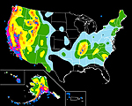
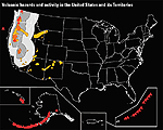
| Earthquake Risk: probability of 6.0 minimum magnitude event within next 50 years | ||||||||||||||||
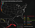
| Tsunami Risk: assessed based on historical events over past 1,100 years | ||||||||||||||||
| Hurricane Risk: prediction of number of hurricanes over a 100-year period based on historical events | ||||||||||||||||
| Flood Risk: assessed based on flooding-related disaster declarations between 1965-2003 | ||||||||||||||||
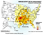
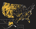
| Tornado Risk: assessed based on number of tornadoes between 1953-2004 | ||||||||||||||||
| Volcano Risk: assessed based on historical events over past 10,000 years | ||||||||||||||||
| Wildfire Risk: assessed based on number of wildfires over 250 acres between 1980-2003 | ||||||||||||||||
 |
 |
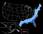 |
| Earthquake | Tsunami | Hurricane |
 |
 |
 |
| Flood | Tornado | Volcano |
 |
|
| Wildfire |
 | Terms & Privacy | Site Map | About Us | Sources | Links | Advertise | Revised: 12/13/2018 Copyright © 2019 Great Places To Retire |